Commercial blended land + bathymetry.
Feature-preserving coastlines.
The world’s first commercial blended
land-and-bathymetry terrain platform, engineered
with attractive coastal collaring and
feature-preserving coastlines. Stream a continuous
global surface built for serious GIS, simulation and
enterprise geospatial infrastructure.
QuantizedMesh.com is designed as a portable terrain
foundation rather than a viewer-specific product. Deploy
the same global terrain through CesiumJS, MapLibre,
deck.gl or iTowns — choosing the rendering ecosystem
that best fits globe visualization, web mapping,
analytical overlays or immersive 3D geospatial
applications.
The terrain engine is built around adaptive
triangulation rather than a single rigid meshing
strategy. Regular Grid, Feature-Aware Grid TIN and
Adaptive Delaunay options let geometry respond to
terrain character while retaining efficient streaming
and seamless tile continuity.
Adaptive terrain geometry
Multiple TIN strategies allow terrain construction
to preserve meaningful ridgelines, cliffs, valleys
and morphology without spending equal geometric
complexity everywhere.
Regular Grid · Feature-Aware Grid TIN · Adaptive
Delaunay
↗
Lighting-ready vertex normals
Per-vertex normals provide richer surface curvature
and realistic shading cues, giving modern globe
engines the information they need for detailed
terrain lighting.
Accurate land/water classification is designed to
preserve intricate shoreline detail, small islands
and inland water features instead of reducing
coastlines to coarse transitions.
Shoreline fidelity · islands · inland water
◎
Continuous global terrain
Coverage spans 90° north to 90° south, with
progressive streaming from global overview levels
through enhanced regional detail where
higher-resolution source coverage is available.
Pole-to-pole · progressive LOD · one coherent
surface
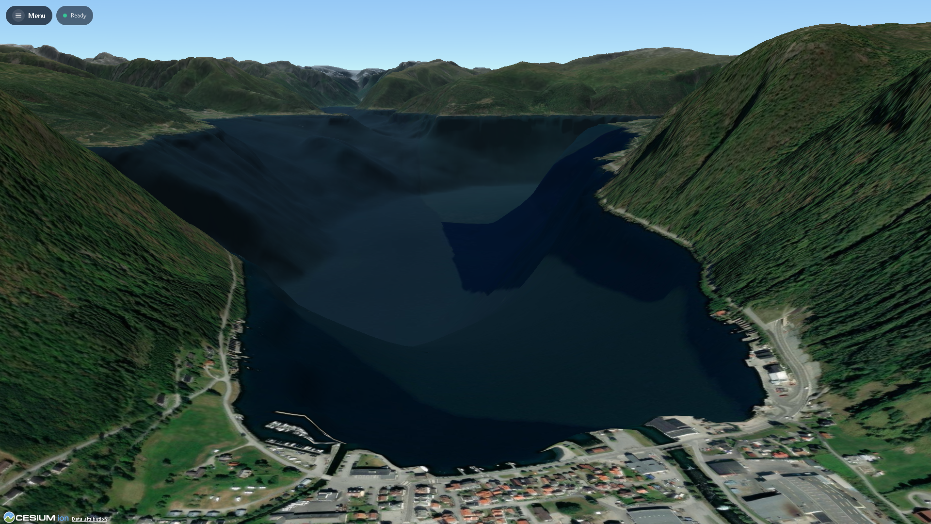
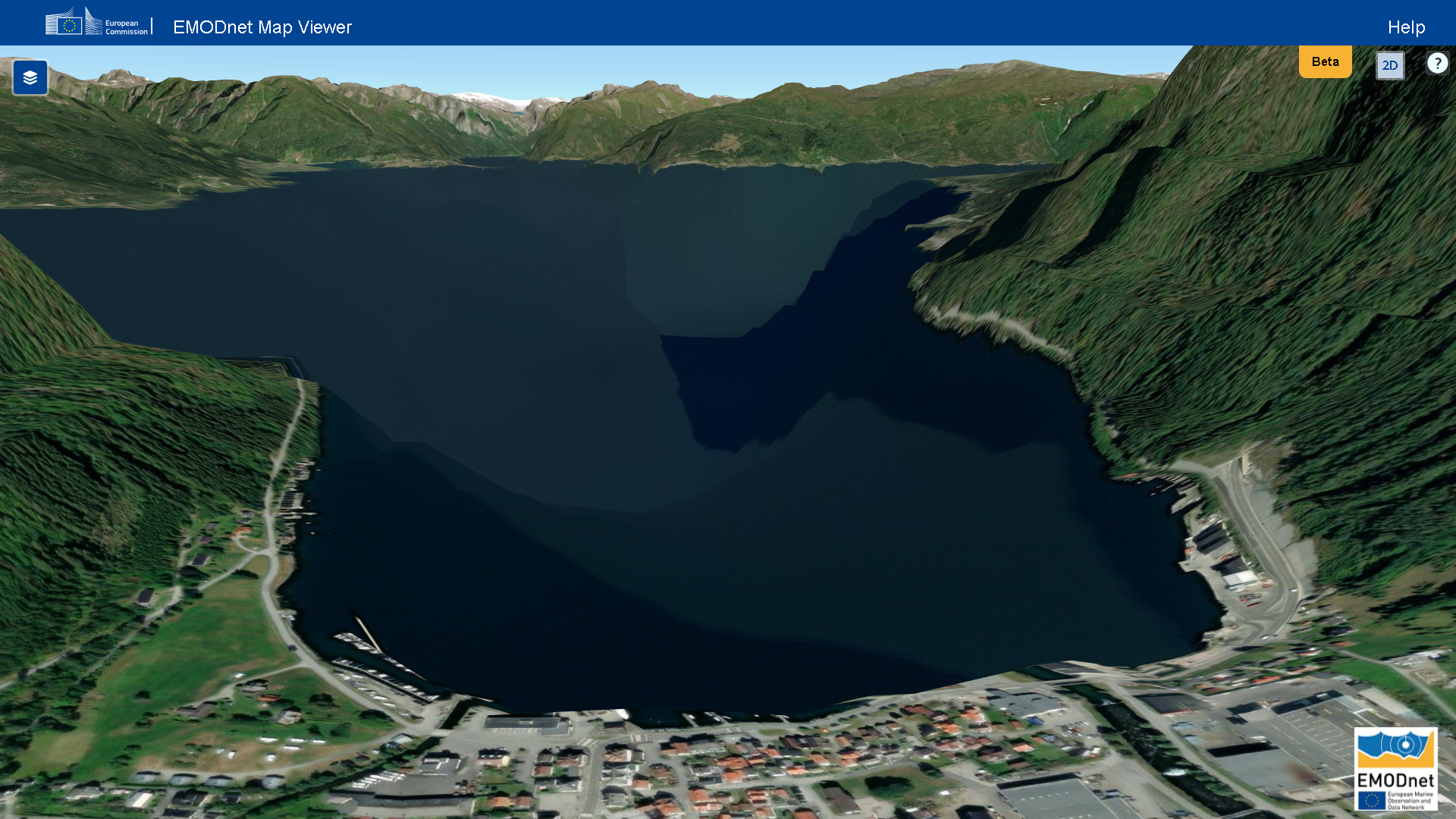
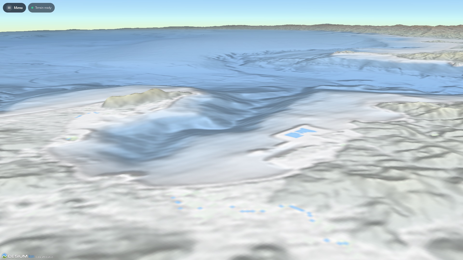
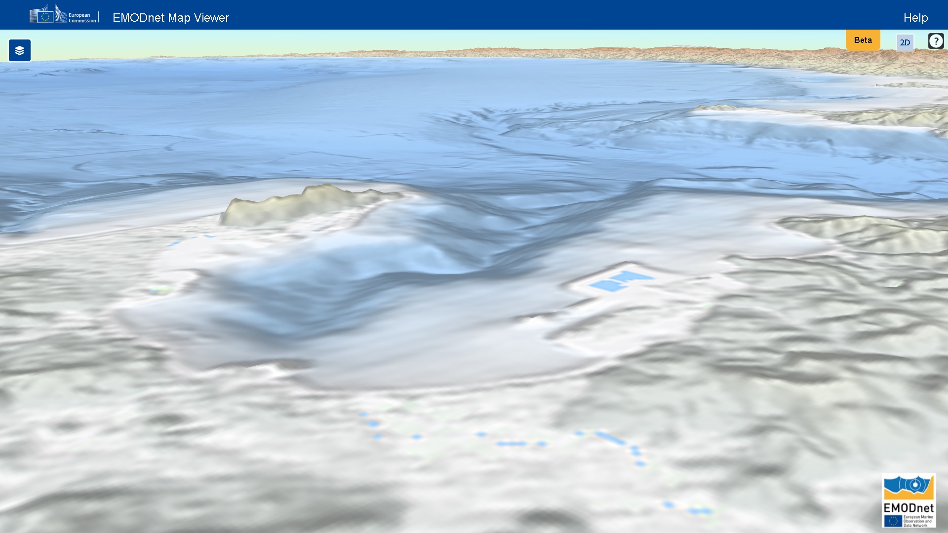
In these representative side-by-side views,
panDEM bathymetry closely matches the
terrain character visible in EMODnet, while the
coastal collaring removes unnatural cliffs at
land-to-water transitions. The comparison
highlights the level of seafloor structure retained
by the production-ready Quantized Mesh surface.
EMODnet Bathymetry images and associated logos are the property of EMODnet and the European Union and are shown here solely for screenshot comparison purposes.
Comparison 01
Comparable oblique terrain view
panDEM
panDEM blended land + bathymetry
EMODnet
EMODnet reference view
Comparison 02
Comparable regional seafloor view
panDEM
panDEM blended land + bathymetry
EMODnet
EMODnet reference view
02 / Global terrain intelligence
Eight source families. One terrain surface.
Rather than exposing disconnected elevation products,
the platform evaluates and combines global DEMs with
authoritative regional topo-bathymetric datasets in a
unified terrain experience. Coverage-aware source
selection, validation and quality controls preserve a
consistent commercial GIS surface across source boundaries.
01
COPDEM 30
Primary high-resolution land elevation and the main
global terrain foundation.
Primary land elevation
02
SRTM 30
High-quality terrain coverage used within the
multi-source integration strategy.
Terrain coverage
03
SRTM 90
Broad-area fallback and continuity where the terrain
engine requires resilient coverage.
Fallback + continuity
04
ASTER
Supplementary regional elevation used to strengthen
source availability and terrain integration.
Regional enhancement
05
GEBCO
Global bathymetry and ocean terrain, integrated with
terrestrial elevations for continuous
land-to-seafloor geometry.
Bathymetry + ocean terrain
06
AusBathyTopo 250 m
Seamless Australian topography and bathymetry used for
higher-detail regional terrain and post-tile fidelity validation.
Australia · regional topo-bathymetry
07
EMODnet DTM 2024
Harmonised European marine bathymetry used as an
authoritative regional source for enhanced seafloor detail.
Europe · regional bathymetry
08
NOAA Coastal Relief
High-resolution U.S. coastal relief integrating offshore
bathymetry and onshore topography for coastal terrain coverage.
United States · coastal topo-bathymetry
One terrain, not a catalogue of DEMs.
The integration layer is designed to maximise worldwide
availability while presenting a consistent product
across hemispheres and source boundaries.
01Global sources
02Coverage intelligence
03Terrain construction
04Global integration
05Quantized encoding
06SQLite deployment
03 / Processing pipeline
Designed once. Streamed everywhere.
Terrain generation happens ahead of production delivery.
Multiple elevation sources are selected, validated and
integrated; neighbour-aware edge management protects
tile continuity; coastline and bathymetry processing
establish a coherent global surface; and the resulting
geometry is encoded as native Cesium Quantized Mesh.
The deployment therefore serves pre-generated compressed
binary terrain instead of paying the computational cost
of creating terrain on demand. The result is predictable
streaming behaviour and lower runtime infrastructure
complexity.
Coastline morphology is treated as a core terrain
feature. Authoritative terrestrial elevations and GEBCO
bathymetry are fused into a visually continuous surface
while preserving recognisable shoreline geometry and
reducing coastal artefacts.
Shorelines, islands, archipelagos, estuaries, canals
and fjords retain recognisable geometry instead of
being blurred by crude transitions.
Seam-safe processing
Neighbour-aware processing and edge management are
designed to minimise visible tile seams and
coastline artefacts.
Continuous bathymetry
The terrain surface continues naturally from
mountains and coastal shelves into shallow water and
the ocean floor.
05 / Enterprise deployment
A planet-sized terrain stack. One portable deployment.
Approximately 850 GB of pre-generated terrain is
delivered from a portable SQLite terrain database,
simplifying hosting, replication and distribution while
keeping runtime terrain generation out of the production
path.
~850 GBSQLite TerrainPre-generated Quantized Mesh
BACKUPREPLICATESTREAM
01
Cloud
Deploy behind scalable terrain services and
distribution infrastructure for high-volume
concurrent access.
02
On-premise
Keep the entire global terrain package within
controlled enterprise infrastructure with
straightforward backup and replication.
03
Disconnected
Portable storage supports isolated and field
environments where dependable terrain must
remain available without external data services.
04
Predictable production performance
Pre-generated terrain reduces server-side
generation overhead, supporting low CPU
utilisation and consistent high-throughput
streaming behaviour.
Quantized Mesh combines compact vertex and triangle data
with terrain-specific extensions. Oct-encoded vertex
normals enrich lighting, watermask data distinguishes
land and water, horizon occlusion metadata supports
globe-scale rendering efficiency, and progressive
quadtree levels-of-detail keep delivery appropriate to
the viewer’s distance.
07 / Mission profiles
One terrain foundation. Many demanding systems.
The platform is designed for professional applications
that value dependable worldwide terrain, visual
consistency, deployment control and predictable
streaming behaviour.
01
Digital Twins
A consistent global surface for city, infrastructure
and planetary-scale 3D environments.
02
Defence & Intelligence
Controlled deployment options for simulation,
visualisation and geospatial mission environments.
03
Aviation
Progressive terrain suitable for terrain-aware
visualisation and synthetic-world applications.
04
Maritime
Land, coastline and bathymetry brought together in
one continuous terrain surface.
05
Simulation
Pre-generated global terrain that supports
repeatable scenarios and predictable rendering
behaviour.
06
GIS & Planning
High-performance 3D context for GIS, infrastructure
planning and environmental modelling.
08 / Data validation
Measured against the source.
Production terrain is validated after tile creation against its source surfaces. The supplied programme records six completed runs across GEBCO Level 10 and three authoritative Level 13 regional datasets, totalling 3,840 terrain tiles and 16,224,000 elevation comparisons with zero failed tiles and zero invalid samples.
VALIDATION RECORDTraceable post-tile fidelity
Review source datasets, survey coordinates, reference systems and residual statistics for GEBCO, AusBathyTopo, EMODnet and NOAA Coastal Relief Model validation runs.
RUNS6 completeLevel 10 + Level 13
TILES3,8400 failed
VALID SAMPLES16,224,0000 invalid
GEBCO RMSE5.6839 mpooled · 3 Z10 runs
GEBCO MAE3.5000 mmean · 3 Z10 runs
GEBCO BIAS−3.4589 mpooled signed error
GEBCO P9511.6067 mmean regional P95
REGIONAL Z133 sourcesAustralia · Europe · U.S.
Validated source familiescompleted supplied records
Source
Level
Samples
GEBCO
10
12,979,200
AusBathyTopo 250 m
13
1,081,600
EMODnet DTM 2024
13
1,081,600
NOAA Coastal Relief Model
13
1,081,600
COMMERCIAL GIS QA
Source-aware validation, published with context.
Residuals are reported as derivative-fidelity measurements: they quantify how closely the produced terrain follows the selected source after processing, rather than claiming independent ground-truth accuracy.
Regional Level 13 tests retain their own datum and resolution context, while the GEBCO Level 10 record reports a project-specific engineering QA assessment for smoothed global bathymetry.
Commercial terrain infrastructure. From API access to full IP ownership.
Deploy QuantizedMesh.com at the level that fits your
organisation. Choose low-friction API access for rapid
integration, a dedicated on-location or private-cloud
installation for controlled production environments, or
acquire the complete proprietary terrain-generation
pipeline and associated IP for mapping companies that
require full operational ownership.
Built for GIS teams, mapping platforms, digital-twin
operators, simulation providers and geospatial
businesses that need dependable global terrain without
inheriting the complexity of multi-source DEM fusion,
coastline preservation, bathymetric blending and
Quantized Mesh production.
API accessFastest path to production with minimal
infrastructure.Private deploymentOn-location, on-premise or private-cloud
installation.Pipeline + IPFull proprietary production capability for
mapping companies.